Tomer Burg
Ph.D. | School of Meteorology
  • Home
  • About
  • Research
  • Products
  • Code
  • Blog
  • Links
  • Blog Archive - Current Weather

    Filter posts:

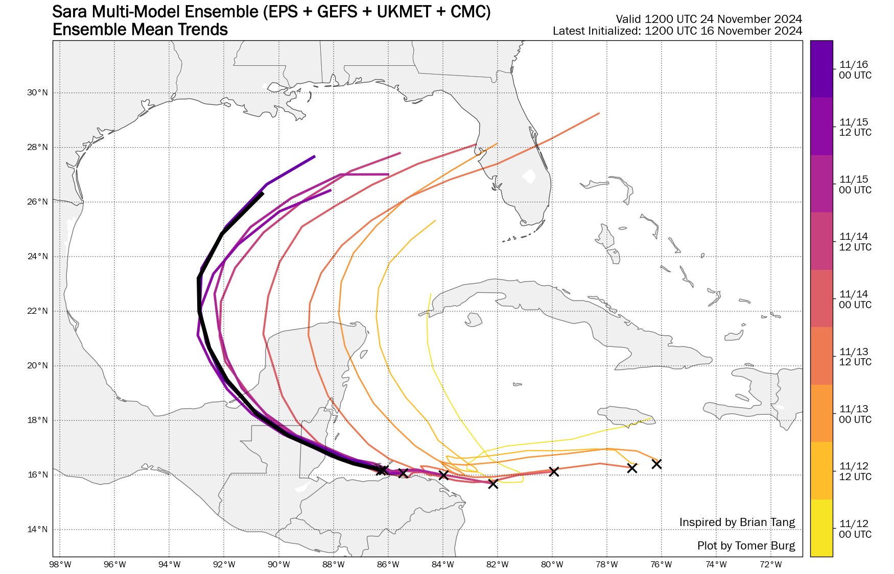
    Tropical Storm Sara: What Went Wrong?
    Tomer Burg | 16 November 2024 | Current Weather
    Tropical Storm Sara is currently producing torrential rainfall and flooding across portions of Central America, and is expected to make landfall in Belize as a weak tropical storm before dissipating inland, with remnant moisture spreading into the southeast U.S. But this was not the original forecast – just a few days ago, many models were consistently showing a hurricane or major hurricane approaching Florida. This post looks at why models showed that outcome, and where the forecast went wrong.

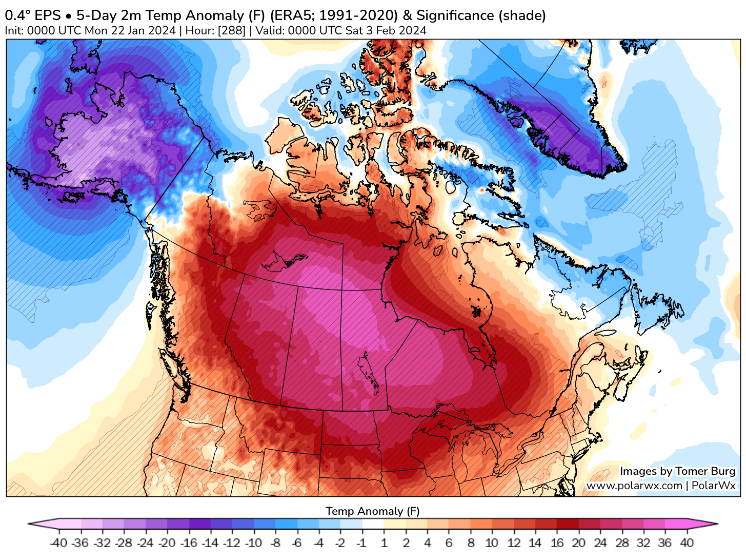
    February Outlook: Mild Start, Colder & Snowier End
    Tomer Burg | 23 January 2024 | Current Weather
    This post offers some quick thoughts and analysis on the extended range pattern heading into the end of January and February over North America, with a focus on impacts over the United States. While the transient January cold outbreak is quickly making way back to widespread anomalous warmth across the continent, not unlike December, not the entire US will experience anomalous warmth, while indications remain for a colder and snowier second half of February in parts of the East Coast.

    January 15-16, 2024: Breaking the I-95 Snow Drought
    Tomer Burg | 15 January 2024 | Current Weather
    This winter has been a unique one across the United States – a lot of heavy rain and wind events in the East Coast, anomalous warmth throughout much of December, a challenging forecast for an early January snowstorm that produced heavy snow in parts of the Northeast, severe weather and tornadoes in parts of the country, and as of this week, two consecutive major cyclones with blizzard conditions in the Midwest.

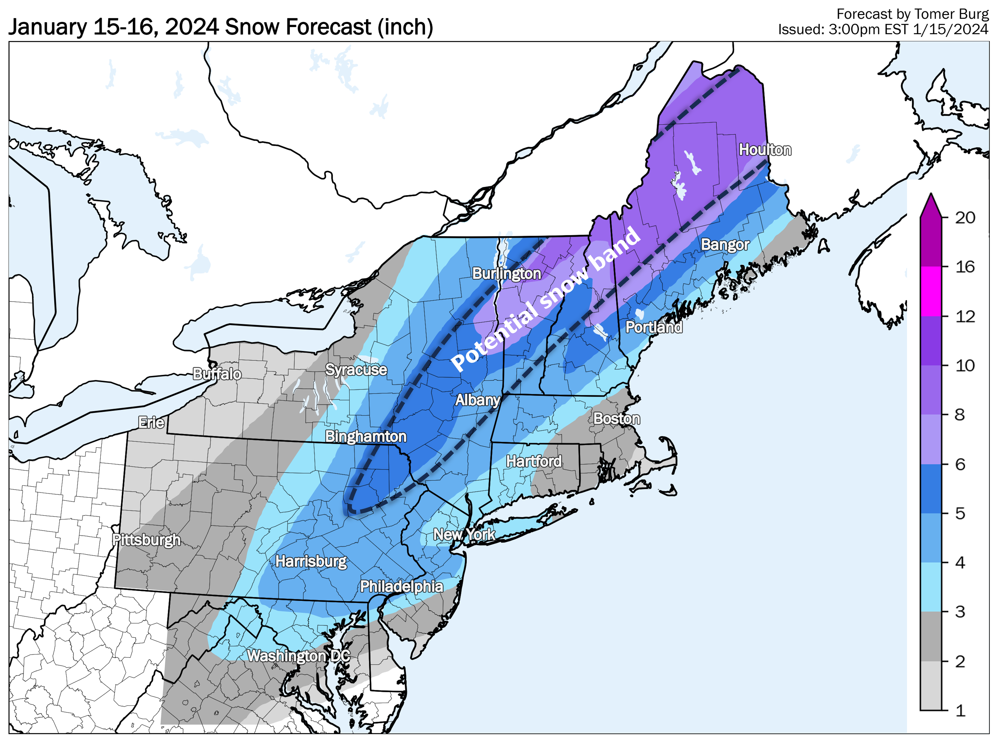
    Two aspects have been notably missing until now: widespread cold, and snow in the major I-95 Mid Atlantic cities. The first changed this weekend as a major cold outbreak is underway across North America. The second is about to change tonight, as a minor to moderate snow event brings the first widespread snow event above 1-3 inches to the I-95 corridor in nearly two years, which this post reviews from a synoptic and mesoscale perspective.

    Tropical Storm Fiona: Challenging Forecast Ahead
    Tomer Burg | 15 September 2022 | Current Weather
    Tropical Storm Fiona, the 6th named storm of this largely inactive Atlantic hurricane season, developed into a tropical cyclone yesterday in the open Atlantic waters. Unlike previous hurricanes Danielle and Earl, Fiona is expected to directly affect large swaths of land with heavy rain, flooding and gusty winds incoming to some of the Caribbean islands. Afterwards, Fiona's forecast becomes highly uncertain, both track and intensity wise, and it is too early to make any definitive calls regarding whether it will directly affect the United States and if so, then where.

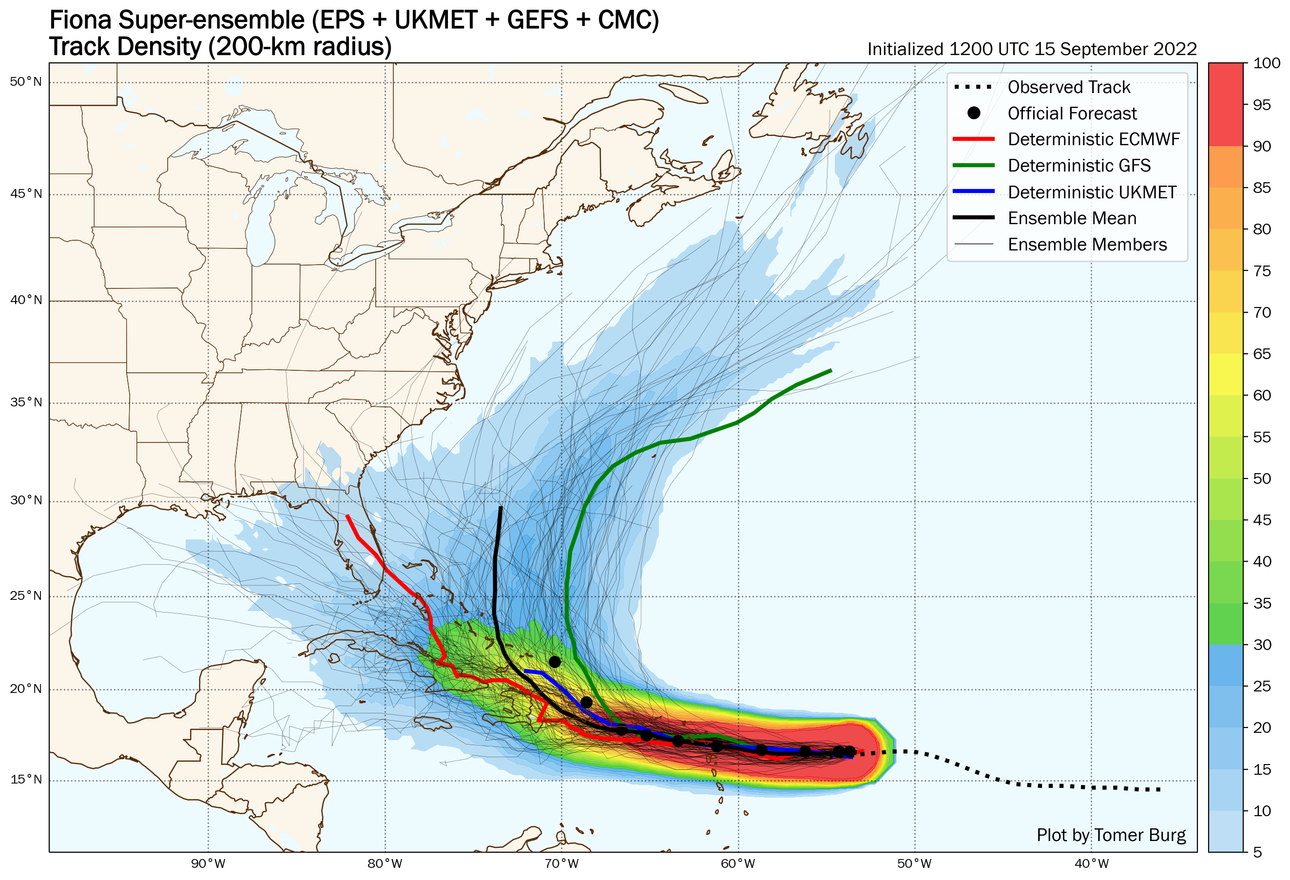
    This forecast post is generally oriented at the public, analyzing the latest observations with Tropical Storm Fiona, why the forecast is so uncertain, and some key points to keep in mind over the next few days as we continue to monitor Fiona.

    Weather Update: Tropics - And CONUS - Are Heating Up
    Tomer Burg | 29 August 2022 | Current Weather
    After an anomalously inactive summer in the tropics, activity is heating up with a rapidly intensifying typhoon in the West Pacific and an invest in the Atlantic Ocean likely to develop into the first tropical cyclone in nearly 2 months. The tropics aren't the only area heating up – an extremely anomalous ridge is expected to build over the western United States, with climatological fall starting on an anomalously hot and for some humid note for much of the continental United States.

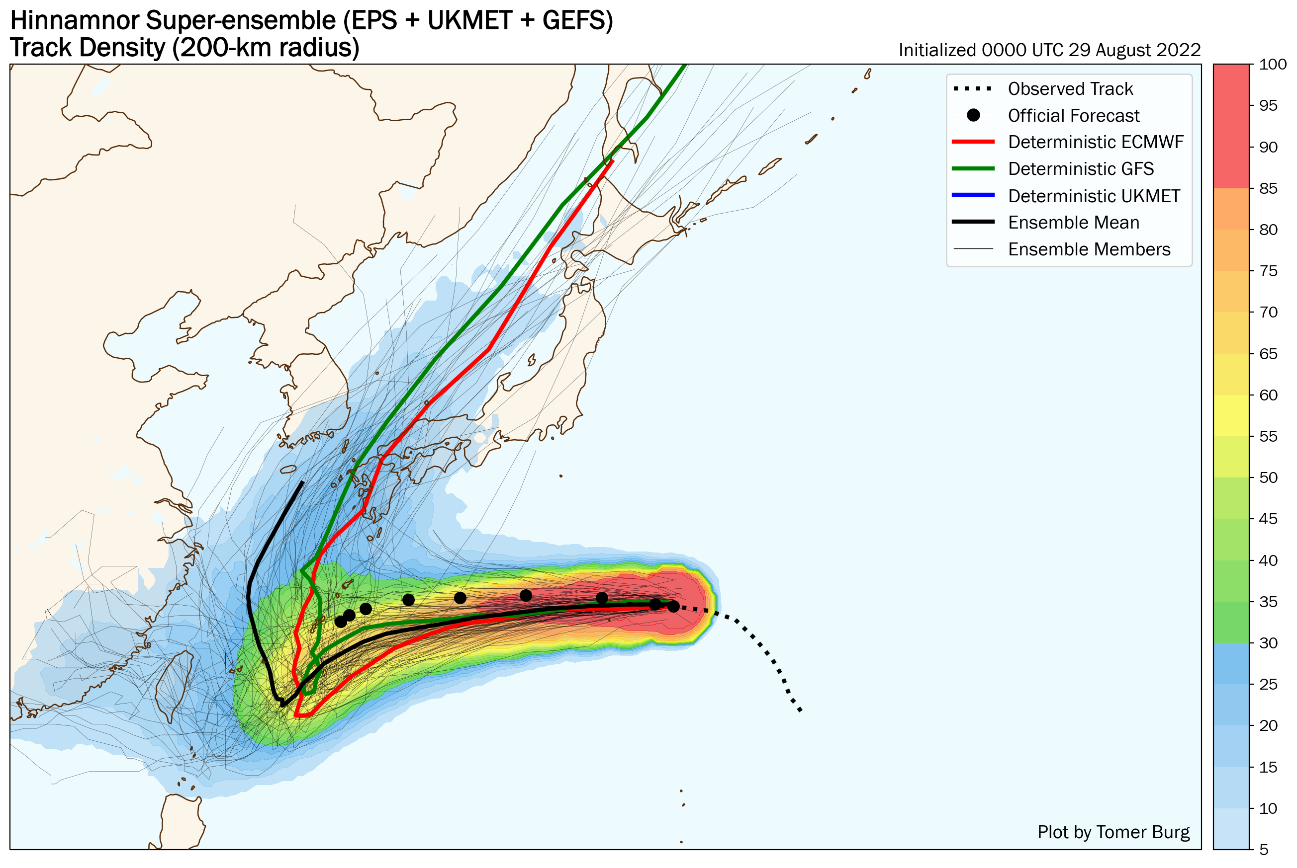
    Today's post looks at the ongoing tropical activity, focusing on Typhoon Hinnamnor and Invest 91L and their respective track and intensity uncertainties, as well as the heat expected over the CONUS and how the amplifying ridge may affect Invest 91L downstream.

    GFS May Hurricane: More Fiction Than Reality
    Tomer Burg | 15 May 2022 | Current Weather
    As the 2022 Atlantic Hurricane Season approaches its onset, numerous deterministic GFS runs have been consistently depicting a hurricane entering the Gulf of Mexico late this month. If this were to verify, this would be highly unusual so early in the hurricane season. But a deeper look shows many red flags that lower confidence in such a scenario.

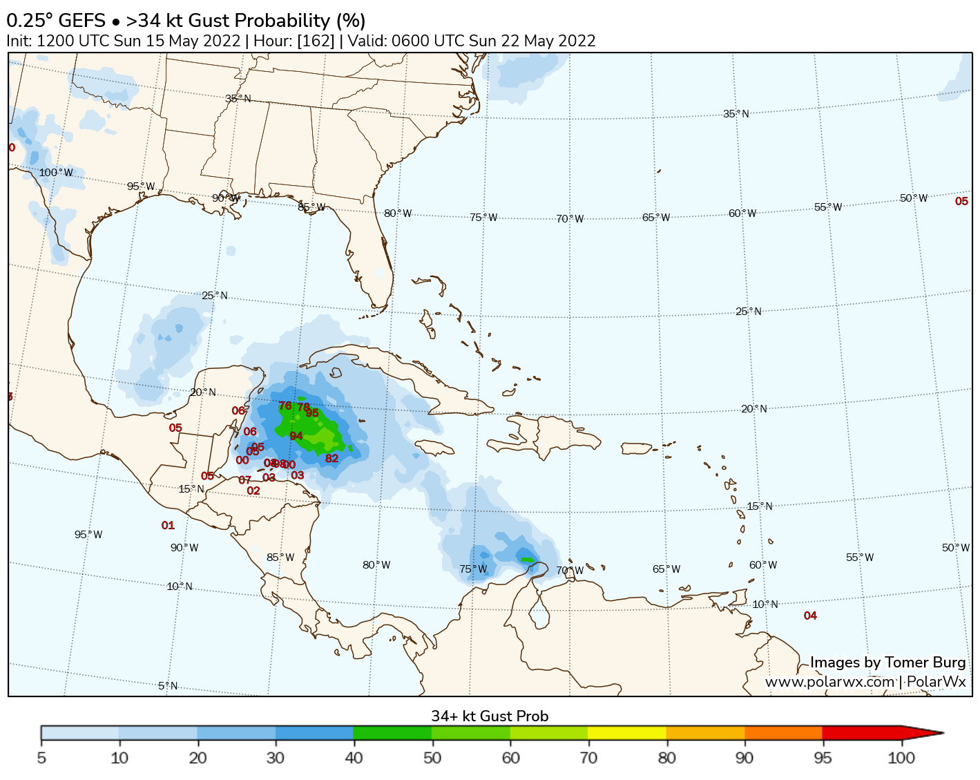
    Deterministic models such as the GFS only depict one of many possible outcomes; ensembles are better suited for determining the range of possible solutions. But like any model, ensembles are susceptible to their own set of biases, such as false alarms for tropical cyclogenesis in the region. All these factors suggest to take the GFS forecast with high caution.

    Late-Season Snowstorm Set to Impact the Northeast U.S.
    Tomer Burg | 18 April 2022 | Current Weather
    After a winter consisting of generally below-average snowfall in the Northeast U.S., followed by abnormally warm conditions through parts of February and March, winter is set to make a brief but notable return for parts of the region as a cyclone deepens while bringing in unusually cold air, resulting in heavy wet snow west of the storm track peaking in the Catskills and Appalachians.

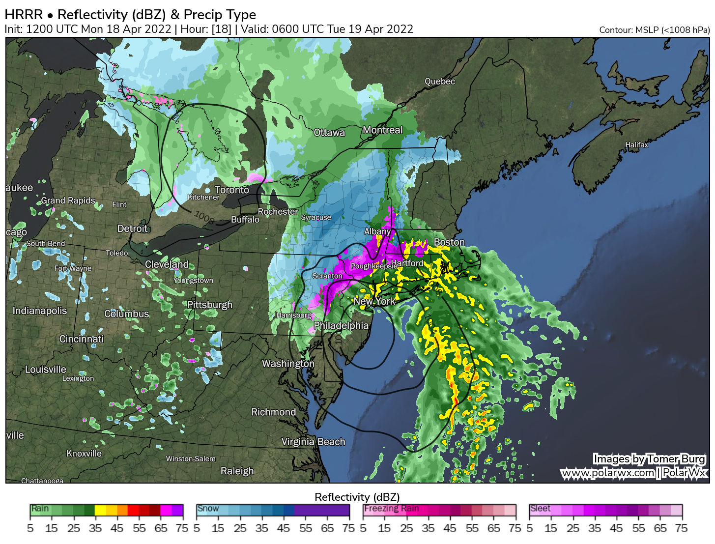
    This post will provide a moderately in-depth overview of what is causing this cyclone to develop and to produce heavy snow, and a look into potential snow totals and other non-snow impacts in the region.