Tomer BurgPhD
All Archived Posts
Current Weather
Meteorology Analysis
Non-Weather Posts
Weather Update: Tropics - And CONUS - Are Heating Up
Tomer Burg • 29 August 2022 • Current Weather

Post Highlights
After an anomalously inactive summer in the tropics, activity is heating up with a rapidly intensifying typhoon in the West Pacific and an invest in the Atlantic Ocean likely to develop into the first tropical cyclone in nearly 2 months. The tropics aren't the only area heating up – an extremely anomalous ridge is expected to build over the western United States, with climatological fall starting on an anomalously hot and for some humid note for much of the continental United States.

Today's post looks at the ongoing tropical activity, focusing on Typhoon Hinnamnor and Invest 91L and their respective track and intensity uncertainties, as well as the heat expected over the CONUS and how the amplifying ridge may affect Invest 91L downstream.
Tropics Overview: Very Quiet Year To Date
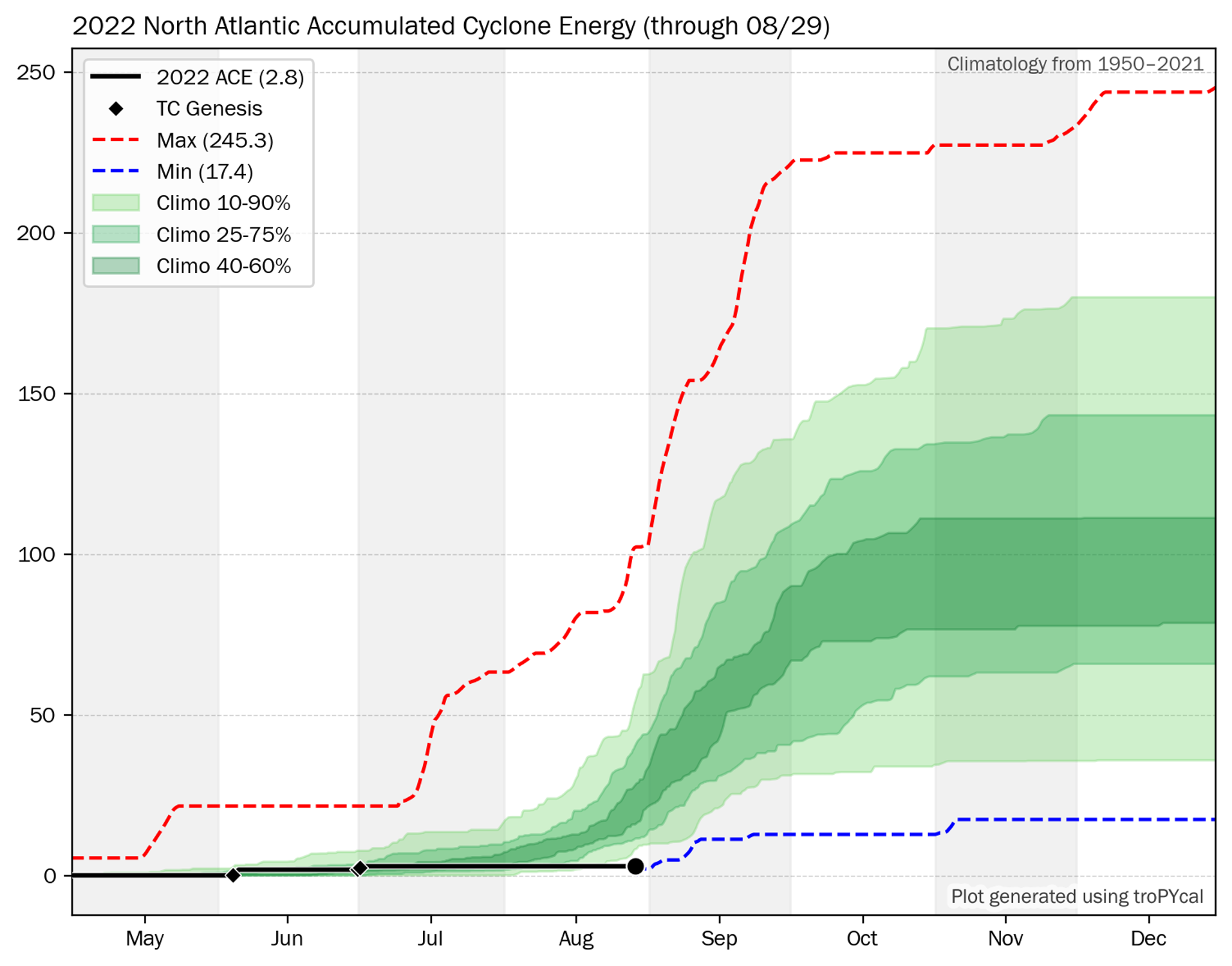
ACE to date for this year in black, compared with the climatology in green.
Climatological peak hurricane season in the Atlantic Ocean often runs from about August 20 to October 10, with the historical peak date of activity on September 10. This year's Atlantic hurricane season has only seen 3 named storms to date, with Accumulated Cyclone Energy (ACE) of only 2.8 units. Not only is this well below average, but this year is currently within the bottom 5 in modern climatology (1950-present) of ACE to date. Should no tropical cyclone (TC) form before the end of August, as is increasingly likely, 2022 will be only the third year in 1950-2022 to feature no August TCs, the others being 1961 and 1997. The last Atlantic TC was Colin on July 3rd, meaning we're nearing 2 months without a single TC despite being in what is typically peak season.

We've had quiet stretches of tropical activity in late August before, but this year has been particularly notable in this absence of activity. In an analysis I did, I took all ACE accumulated from September 1 onward every year from 1950 to 2021 and projected it onto this year's ACE to date, to get a sense of the climatological evolution for the rest of the year. Comparing these results to the median annual ACE, the climatological probability of an above-median ACE year has decreased to merely 29.1%.

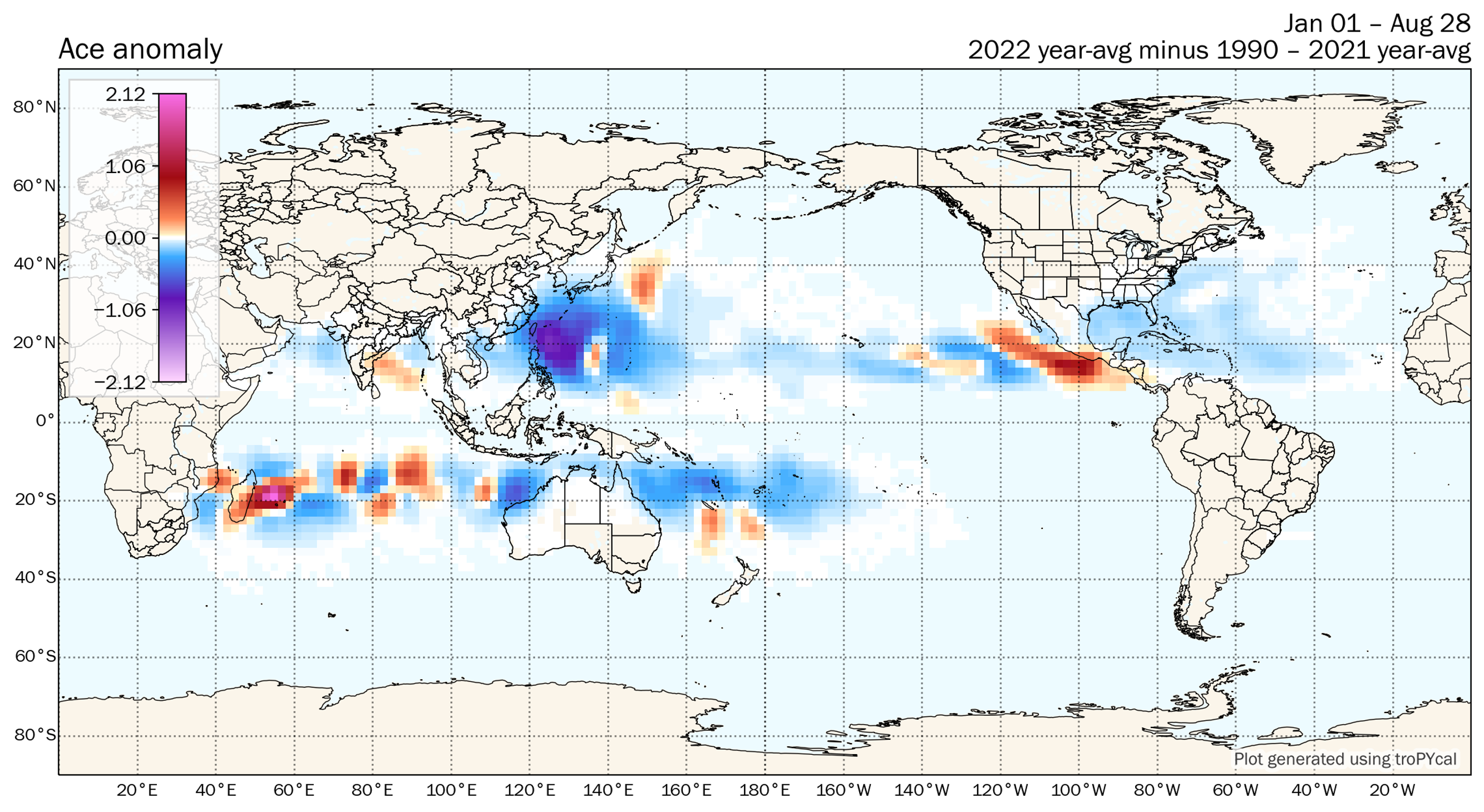
Global ACE anomaly using a 2 degree grid.
This lack of activity is especially notable as most sub-seasonal forecasts called for above to well above normal activity in the Atlantic basin, often citing La Niña conditions and above-normal sea surface temperatures (SSTs). Even though we are still in a La Niña, the Atlantic basin was unexpectedly hostile for tropical cyclone development and maintenance this summer, with stubborn high wind shear and dry air across the basin. It's not just the Atlantic – global TC activity has generally been below average, with the surprisingly active East Pacific basin one of the few exceptions.

Some speculation has also suggested the Hunga Tonga volcanic eruption back in January might have impacted the global climate and potentially indirectly tropical cyclone activity – in the months following the eruption, we've seen extremely high water vapor concentrations in the stratosphere, which cooled the stratosphere resulting in record cold temperatures. Given how recent this was, however, this area will likely require more research to conclusively establish any potential link between the volcanic eruption and global TC activity, and any potential lingering impacts into this winter in the North Hemisphere.
Tropics Watch #1: Typhoon Hinnamnor
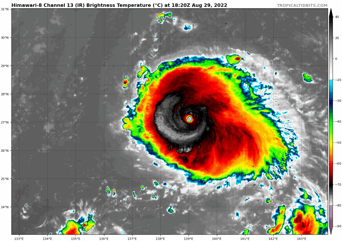
Infrared satellite loop of Typhoon Hinnamnor intensifying, courtesy of Tropical Tidbits.
Tropical cyclone activity has picked up in the West Pacific basin recently after an anomalously quiet stretch, with Typhoon Hinnamnor currently rapidly intensifying while in a favorable high SST, high Oceanic Heat Content (OHC) and low vertical wind shear environment. In the last 12 hours, its maximum sustained wind increased from 75 knots (85 mph) to 125 knots (145 mph), an increase of 50 kt in 12 hours. For comparison, the minimum criteria for rapid intensification (RI) is 30 kt in 24 hours – meaning Hinnamnor is on track to more than double the RI criteria.

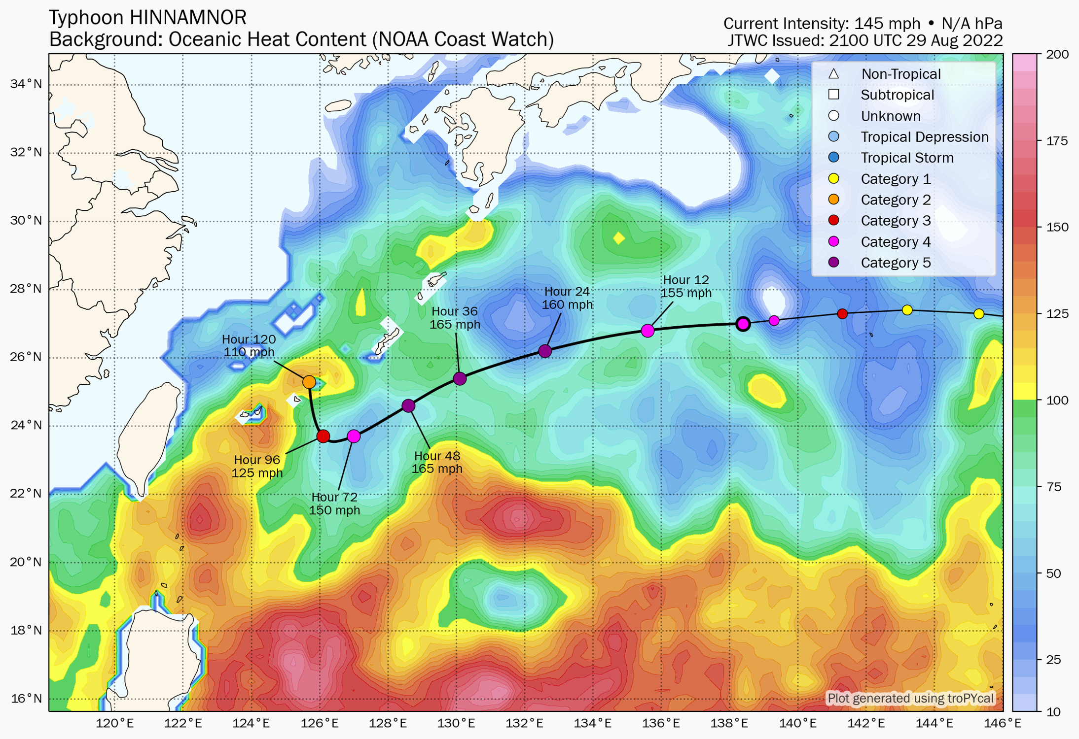
JTWC forecast track for Hinnamnor, with OHC from NOAA Coast Watch in the background.
The latest forecast from the Joint Typhoon Warning Center (JTWC) calls for Hinnamnor to continue intensifying into a Category 5 equivalent Super Typhoon, with maximum sustained winds of 145 kt (165 mph). From an anecdotal perspective, this is one of the highest forecast sustained wind forecast I've seen for a TC that was not a Category 5 equivalent TC at the time of the forecast advisory. While the highest OHC will remain south of its forecast track, it will nonetheless remain in a favorable environment for further intensification barring any internal disruptions such as any eyewall replacement cycles.

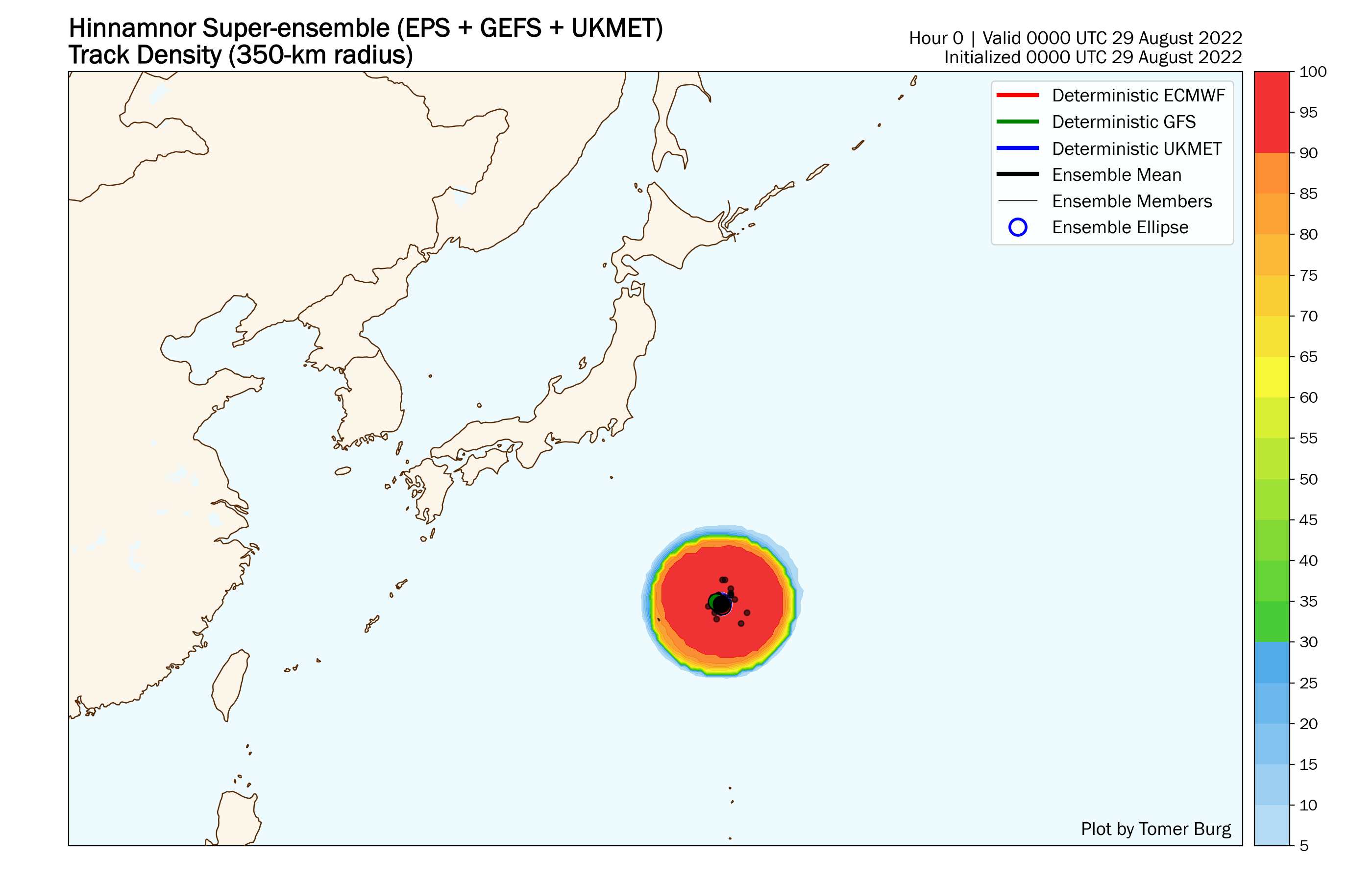
Forecast ensemble tracks from the GEFS, EPS and UKMET ensembles.
Typhoon Hinnamnor's forecast track, however, becomes quite challenging in the longer term. Looking at the 118-member super-ensemble combining the ECMWF, GEFS and UKMET ensembles, we see a notable increase in forecast location spread around 3 September, with some members taking the cyclone west into Taiwan and mainland China, while others recurve it northeast towards the Koreas or Japan. After initially remaining in an area of weak steering currents with ridging to its east and west, a shortwave trough is expected to approach from Mongolia – if Hinnamnor has not travelled too far southwest by then, it will likely get picked up by the trough and recurve, but if it continues tracking southwest more than expected in the short-medium range, it may end up missing the trough and tracking west. Regardless of the outcome, this bears close watching over the coming days.
Tropics Watch #2: Invest 91L
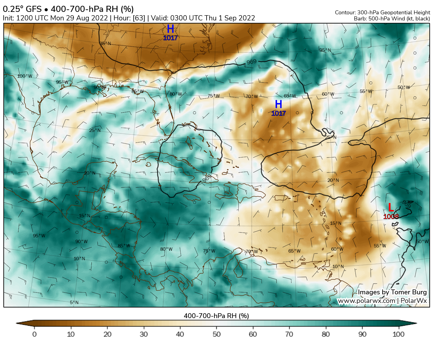
GFS forecast 400-700 hPa averaged relative humidity (%), with 300-hPa height in solid black contours.
Switching gears back to the Atlantic basin, we have Invest 91L in the Main Development Region (MDR), with the National Hurricane Center (NHC) assigning it a 50% chance of becoming a tropical cyclone in the next 2 days, and an 80% chance in the next 5 days. So far, the MDR has been anomalously quiet this hurricane season with zero development – this would be the first MDR development of the year should it materialize. As previously noted, shear and dry air have been primary inhibiting factors across the Atlantic this month, and 91L is no different so far. A dry air mass remains entrenched just to its west, along with an upper-level low aiding to induce some wind shear in the region. Any development over the next 3-5 days will likely remain slow.

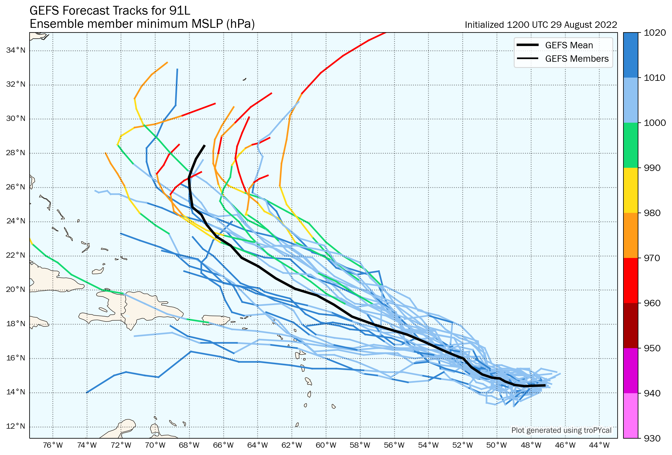
GEFS ensemble forecast tracks for 91L, colored by minimum pressure.
Most deterministic and ensemble guidance similarly shows 91L struggling to organize much in the coming days. Afterwards, it's projected to enter a more favorable environment with less dry air, higher SSTs and potentially lower shear, which would favor intensification as it approaches the region between the Bahamas and Bermuda. Notice that the vast majority of ensemble members show 91L recurving offshore, potentially affecting Bermuda but likely failing to directly affect the continental United States. Read onto the next section for more on what's causing the likely recurve out to sea...
United States: Heating Up in the West
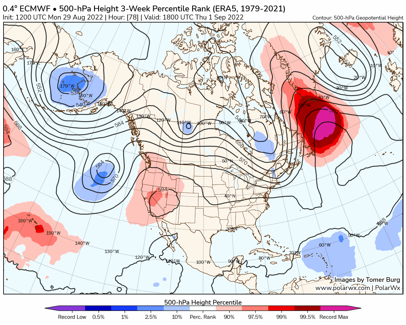
ECMWF forecast 500-hPa geopotential height (dam), and climatological percentile ranks.
It's been a hot and generally dry summer for much of the United States, with a couple of extreme flash flooding events mixed in between. Climatological fall begins on September 1st, and indications are that it'll start off on an anomalously hot note in the western United States as a stubborn deep NE Pacific trough aids in the downstream amplification of a highly anomalous 594-600 dam 500-hPa ridge centered over the Rockies. While this far out there's uncertainty regarding exactly how hot it gets, early forecasts show temperatures surpassing 100 degrees across parts of California.

Notice that the flow downstream of the ridge is blocked as well by a highly anomalous ridge over Greenland. Consequently, multiple troughs are digging into the eastern United States – not particularly cooler than normal, but enough to at least keep the worst of the heat at bay in the Northeast US. This occurs around the same time Invest 91L approaches the Bahamas, and most ensemble members that don't show 91L too far south in the first place end up recurving it well off the US East Coast as troughing remains in place. While of course plenty can change with the forecast this far out, and additional monitoring is necessary, at this time odds of Invest 91L directly affecting the US East Coast appear to be fairly low.
Share this post: