Tomer BurgPhD
All Archived Posts
Current Weather
Meteorology Analysis
Non-Weather Posts
Tropical Storm Sara: What Went Wrong?
Tomer Burg • 16 November 2024 • Current Weather

Post Highlights
Tropical Storm Sara is currently producing torrential rainfall and flooding across portions of Central America, and is expected to make landfall in Belize as a weak tropical storm before dissipating inland, with remnant moisture spreading into the southeast U.S. But this was not the original forecast – just a few days ago, many models were consistently showing a hurricane or major hurricane approaching Florida. This post looks at why models showed that outcome, and where the forecast went wrong.
Background: Models Show a Hurricane
Let's say you're a weather forecaster/meteorologist who communicates the latest forecast to the public, and has an audience from Florida that follows your updates. You know it's been a rough year for Florida – just in the last 2 months, Hurricanes Helene and Milton caused devastation in parts of the state, not to forget mentioning Hurricane Debby in August. Just a few days ago, the Keys were missed from the worst of Hurricane Rafael, which passed not too far to the west. Naturally, people will be concerned if a hurricane is mentioned again in the forecast.

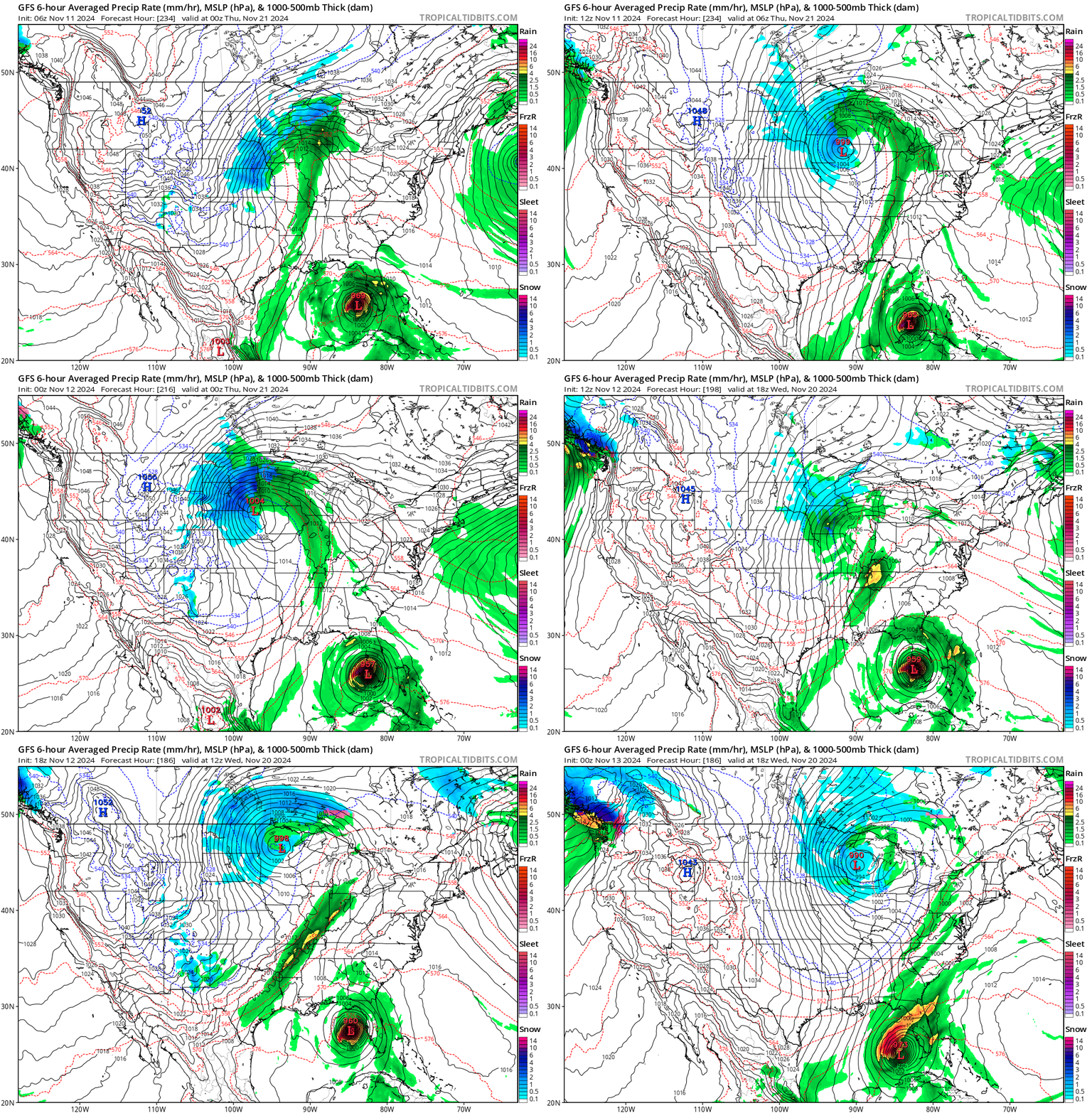
Trend in the last 7 runs of the GFS up through the evening of November 12, 2024.

Now let's say it's November 12. You check the Global Forecast System (GFS) model, as you typically do, and see it showing a major hurricane approaching the same part of Florida affected by Milton and Helene. You already see posts on social media using just that GFS run saying "MAJOR HURRICANE SARA expected to HIT FLORIDA, you have been WARNED!!", and think to yourself "it's just one run of a deterministic model, this is just clickbait". You are also initially skeptical as you've seen these exact same clickbait posts for Hurricane Rafael, which ended up not directly affecting Florida with hurricane conditions.

But you still want to check more data, just to know for sure if it is clickbait or not. So you look at the trend in the last 7 runs of the GFS – and to your surprise, every single run shows a hurricane hitting the same region of Florida! Yes, it is still over a week away, but that run-to-run consistency gets you to start taking this scenario a bit more seriously. You also note how consistent not only the signal for a hurricane is, but also the part of Florida that it hits.
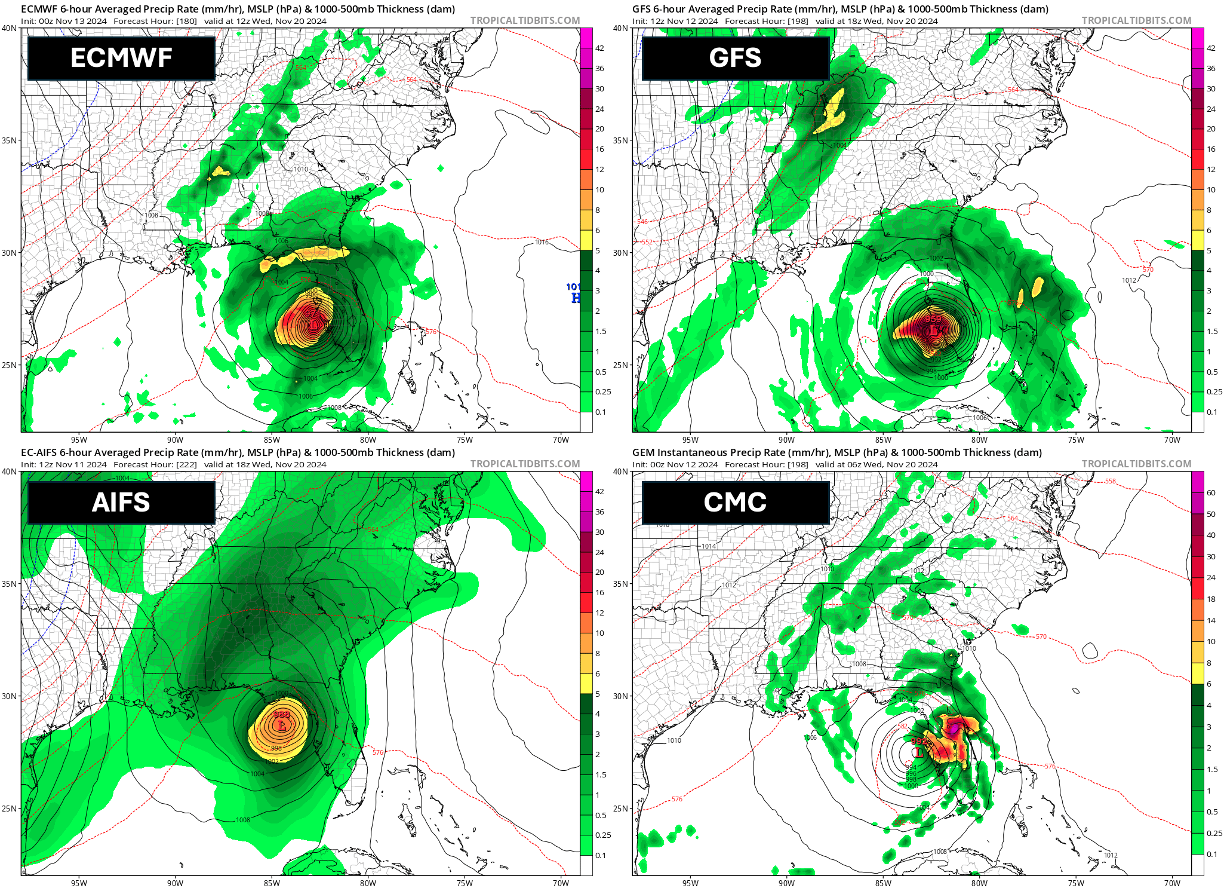
So it's not just the GFS... all of these deterministic global models on November 11-12 also showed a hurricane affecting Florida.

Your next thought is to check other models to see if the same signal is still there. Even if the GFS is consistent run-to-run, it can be consistently wrong sometimes. It does sometimes have a false alarm bias – meaning it spins up tropical cyclones in the long range that either don't develop, or are much weaker than it showed. This does have precedent – take this example from May 2022 of a fantasy GFS hurricane that never developed.

You start going through all of the other global deterministic models. The CMC (Canadian model) shows a sheared tropical storm. ICON (German model) shows a hurricane entering the Gulf of Mexico en route to Florida at the end of its run. Most alarmingly, the ECMWF (European model), which sometimes underestimates hurricanes in the medium range, also shows a major hurricane approaching Florida in multiple runs, and ECMWF's AI model (AIFS), which has done well with identifying potential hurricanes at longer lead times this year, also shows a hurricane affecting Florida.
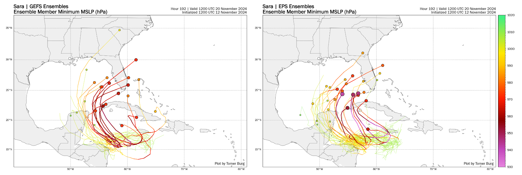
GFS (left) and ECMWF (right) ensembles with many members showing a hurricane approaching Florida. Darker colors and larger dots indicate a stronger storm, while brighter colors and smaller dots indicate a weaker storm.

After looking at all of these signals, you become convinced there is a legitimate signal here and not a fluke. Some people might see this and be convinced this is enough of a signal to raise alarms for a likely Florida hurricane landfall. But you might still not be fully convinced, and at this point, think to yourself "these are just deterministic models – what do ensembles show?". And this is a fair question to ask. Deterministic models are only one possible outcome – there is always uncertainty in the exact initial state of the atmosphere used to initialize the models, and uncertainty in the small-scale physical processes that are too small to be explicitly calculated by weather models (these are called "parameterizations"). Ensembles apply perturbations to the initial state of the model, and these physical processes, to account for that uncertainty, and the result is a larger range of possible outcomes.

You check the GFS ensembles (GEFS), which is a 31-member ensemble, and the ECMWF ensemble (EPS), which is a 51-member ensemble. Many ensemble members also show a major hurricane approaching Florida. There is more variability than the deterministic runs, however – some ensemble members have the hurricane staying south/east of Florida, others have a tropical storm instead of a hurricane approaching Florida, and there's a small but noticeable subset of ensemble members that don't even bring the storm to Florida. Instead, they just have a weak storm lingering near the Central American coast.
The Dilemma: At this point, you may be tempted to brush those weak ensemble members off – you might think to yourself "these are global ensembles, they have a lower resolution than deterministic models meaning they struggle to resolve small-scale processes associated with hurricanes". You look at the Caribbean which has very warm water temperatures and low vertical wind shear, factors which are favorable for rapid intensification of a hurricane. You might think back to Hurricane Milton, where global models and ensembles were too weak with the storm, or Hurricane Oscar, where global models completely missed the development of a small but intense storm.

You may still be tempted to brush those members off... but should you? You think back to other times when models were too strong with a hurricane, or showed a signal for a hurricane that didn't actually happen. But you think practically, about how Florida is still recovering from the devastation of multiple hurricanes, and realize that a lot of lead time is needed to prepare for another hurricane should it actually affect Florida. You start to weight the pros and cons of how much you should warn people about a potential hurricane over a week away.

If you warn too strongly about a hurricane too early and a storm doesn't happen, you risk being seen as exaggerating a forecast for engagement, or worse yet, preying on people's fears. If you wait until there's a stronger forecast signal and warn too late, and the hurricane does hit Florida, you risk giving people and decision makers too little time to prepare, or worse yet, be accused of withholding important information from the public – after all, everyone could see that models showed a hurricane over a week away.

Before we go into what is actually happening and where things went wrong, let's take a look first at the meteorology behind this storm, why models consistently showed a major hurricane approaching Florida over a week away, and why there was still a small subset of models that didn't show a hurricane.
Meteorology of Sara's Forecast

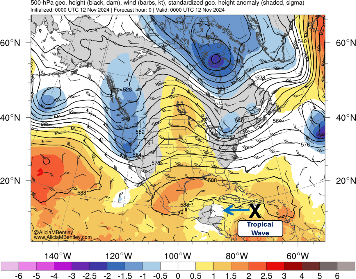
GFS analysis of 500-hPa geopotential height anomaly (dam) vs. CFS climatology valid 0000 UTC 12 November 2024. Image courtesy of Alicia Bentley.

This section is more meteorologically technical. If you're less interested in this section, skip ahead to the next one.

Even though Sara in the end is not going to affect Florida as a hurricane, the synoptic pattern is as favorable as can be for one – the only missing ingredient was a hurricane entering the Gulf of Mexico. Before we get into where models went wrong, to understand why models consistently showed the outcome that they did, let's first zoom out to the broad picture.

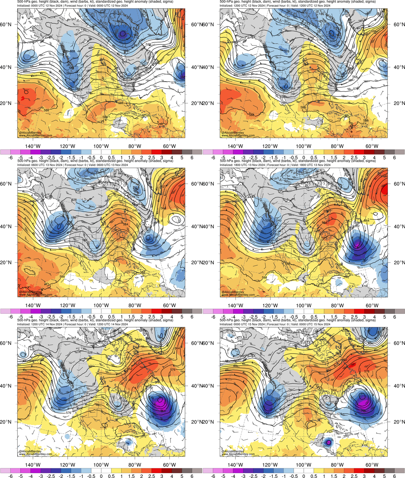
This plot shows geopotential height at the 500 hPa pressure level (about 5km altitude) in black contours, and height anomaly relative to climatology in fill, valid on the evening of November 11. A vigorous tropical wave that entered the Caribbean Sea a few days earlier was gradually moving westward, producing more intense convection than most models previously depicted. This tropical wave was being steered westward by a mid-upper level ridge to its north. At that time, there was nothing remarkable yet in the midlatitudes to its north, but that would change later.

GFS analysis of 500-hPa geopotential height anomaly (dam) vs. CFS climatology from 0000 UTC 12 November 2024 through 0000 UTC 15 November 2024. Image courtesy of Alicia Bentley.

Over the next 3 days, multiple important events happened in the midlatitude waveguide that set up the stage for any tropical disturbance that would have stayed far enough from the Central American coast to develop into a hurricane and move towards the Gulf of Mexico:
  • Western US troughs: Two troughs entering the western US in quick succession both provided forcing for height rises downstream, resulting in a ridge building over the eastern US and the eastern half of Canada. Due to the short wavelength between these two troughs, the lead trough split into a cutoff low over the Ohio Valley.
  • North Atlantic blocking: A retrograding block over the North Atlantic propagating from east to west merged with the aforementioned ridge building over eastern North America. This evolution trapped a cutoff low to its south, which dug deep into the subtropics and became quasi-stationary. This setup is known as a "Rex block".
  • Trailing West Coast trough: The trailing trough over the western US continued digging deep into the western US, and eventually the Southwest. This trough forced ridge building downstream over the southern Great Plains and the western Gulf of Mexico.
The evolution described above affected the environment around the precursor disturbance to Sara by eroding the ridge to the north and amplifying a separate ridge to its northwest. Had this disturbance stayed north of Central America, it would have come to a near-stall over the western Caribbean. Given very warm – and deep – sea surface temperatures over 29°C, and low vertical wind shear, this would have provided a favorable environment for a hurricane to form while slowly meandering over the western Caribbean.

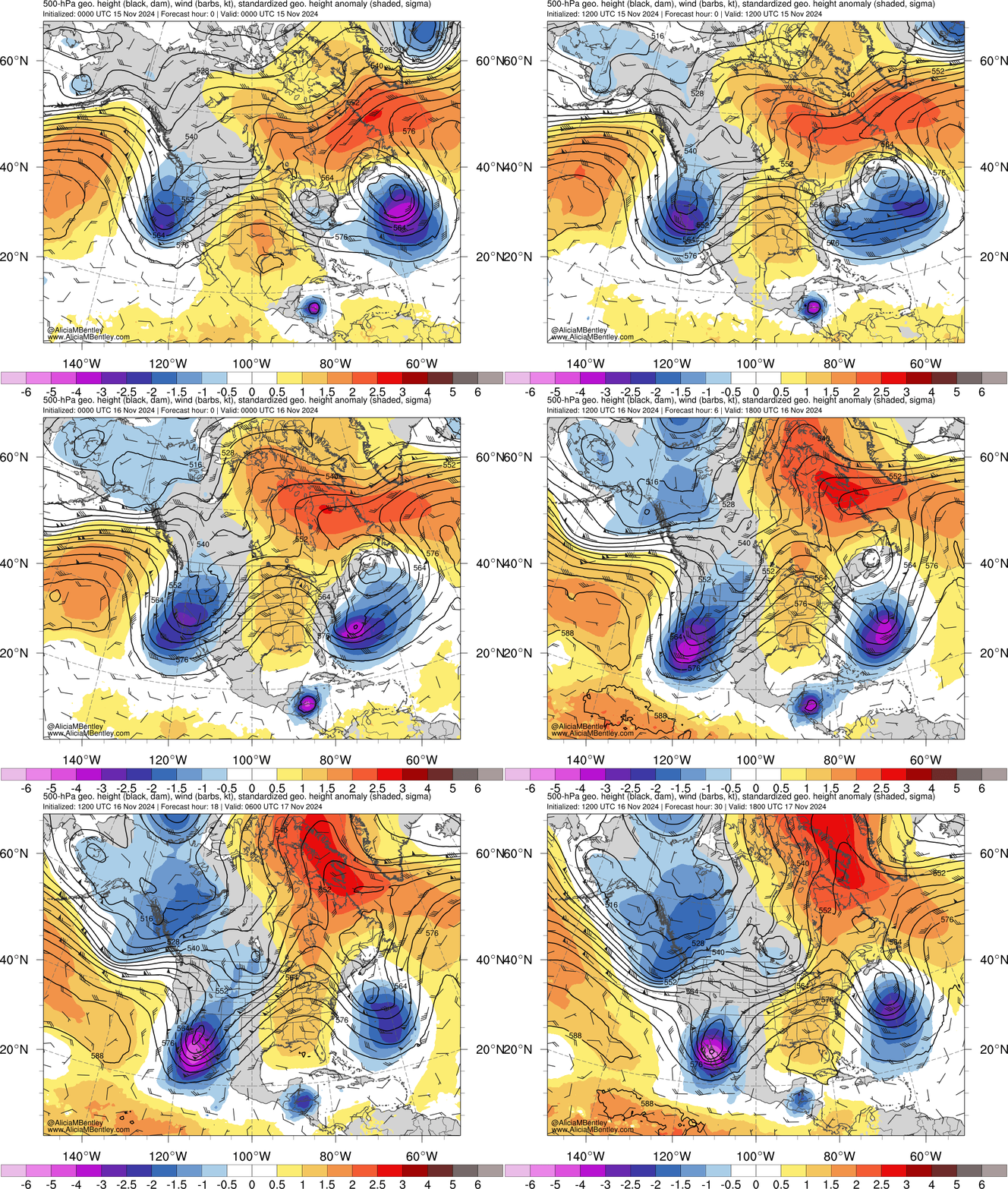
GFS analysis of 500-hPa geopotential height anomaly (dam) vs. CFS climatology from 0000 UTC 15 November 2024 through 0000 UTC 18 November 2024. Image courtesy of Alicia Bentley.

Over the next few days, the trailing West Coast trough continued to dig into the Southwest US. Along with the trough over the Northwest Atlantic drifting to the east, this contributed to a ridge amplifying over the Southeast US. Consequently, the previously weak steering flow over the western Caribbean gradually becomes southeasterly. Continuing with our hypothetical scenario before where the antecedent disturbance stayed farther from Central America, and developed into a hurricane, the ridge building to its north would have steered an intensifying hurricane northwest, which would have taken it towards the channel between the Yucatan Peninsula and western Cuba.

At this point, once entering the Gulf of Mexico, such a storm would have felt the influence of strengthening southwesterly flow from the jet stream to its north and turned to the northeast. While wind shear, cooler water temperatures and drier air would have weakened such a hurricane in the Gulf of Mexico, it would have still been strong enough to produce substantial impacts in the Southeast US and nearby regions (e.g., Bahamas, Cuba).

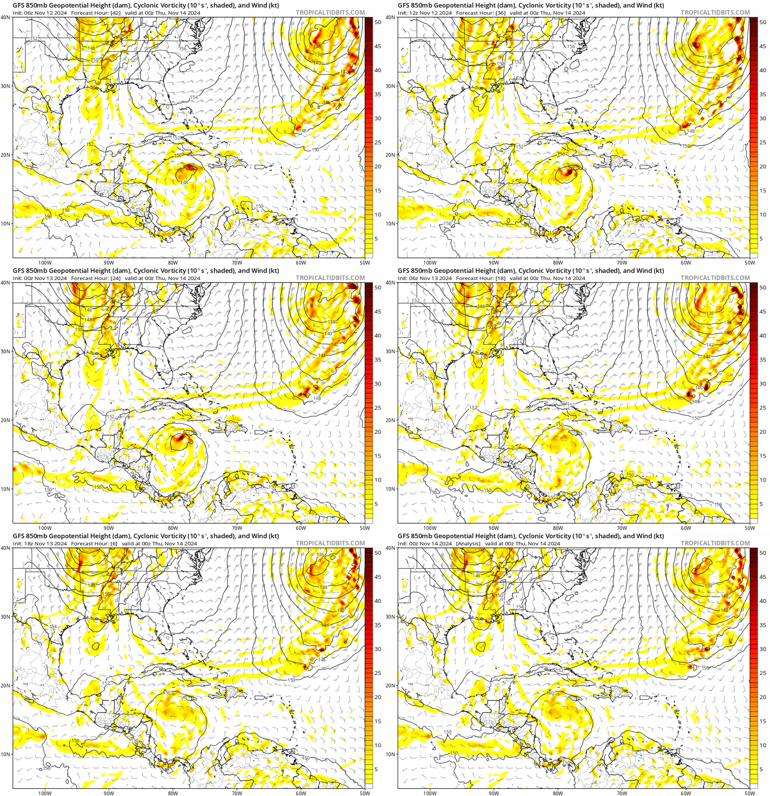
Trend in GFS 850-hPa vorticity valid 0000 UTC 14 November 2024, for cycles initialized from 0000 UTC 12 November 2024 (hour 42, first image) to 0000 UTC 14 November 2024 (hour 0, last image). Image courtesy of Tropical Tidbits.

The synoptic pattern as described above is currently unfolding as we speak – the midlatitude pattern is remarkably similar to what models predicted a week ago. The only missing ingredient compared to what models had a few days ago is a hurricane developing and entering the Gulf of Mexico. The general theme of where models went wrong is consistent, but the specifics between each model vary.

In the case of the GFS, shown above, the 850-hPa vorticity maximum associated with the disturbance verified weaker, farther south, and faster than modeled just 1-2 days prior. In the case of the ECMWF (not shown here), the vorticity maximum was farther south and slightly faster than previously modeled. In both models' cases, this adjustment was most pronounced early on November 13th, which coincided with these models abruptly trending away from a hurricane entering the Gulf of Mexico.
Why is this important? This may sound like only a minor adjustment – and it is in scale – but it had a crucial impact on later evolution of the forecast. With a faster and farther south disturbance, not only was it quickly steered right into the coast of Honduras, where it made landfall yesterday (November 15), but its stalling location (it is currently near stationary) is west of where models previously showed it. This prolonged land interaction prevented a more intense storm from developing had it stalled just 100-200 miles to the northeast of where it verified, as models showed earlier. Typically, 100-200 mile errors may not result in such a major change in the longer range forecast, but when this makes the difference between a storm rapidly intensifying over open water and land interaction preventing a storm from rapidly intensifying, even these small short-term errors are crucial.

Where did models go wrong? This question is more complicated to answer, and would require more in-depth modeling studies to understand exactly what happened. There are several potential explanations, however. One is that the ridge to the north was stronger than previously modeled, which may have steered the disturbance faster than initially predicted. In the case of the GFS, it is possible that a weaker vortex than initially modeled resulted in the storm being steered more to the SW by the low-level steering flow, whereas a deeper vortex would likely have had less of a southerly motion component. There is also the possibility of models struggling to resolve the low-level structure of the disturbance, as there had not been recon flights to sample the disturbance at that time.

Situations like this are where ensembles add value. If you recall previously, some of the ensemble members for the GEFS and EPS showed only a weak tropical storm along the Honduras coast, instead of the hurricane farther over open water that other ensemble members – and most deterministic models – were showing. As ensembles account for variability in initial conditions, some members did show the disturbance farther south and slightly faster than their parent model showed, which allowed them to represent the correct outcome before the rest of the ensemble members and model guidance caught on. This may be obvious in hindsight, but of course, hindsight is 20/20 – at that time, it was difficult to know for sure if this subset of members was a legitimate signal or a fluke.
Takeaway Points

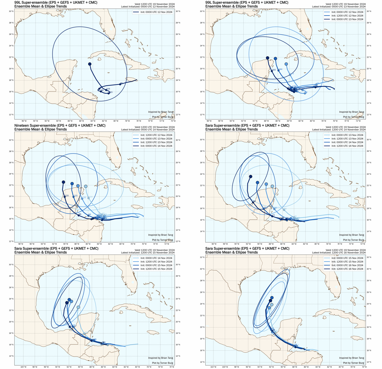
Trend in the multi-model ensemble mean track (solid line) and ensemble spread ellipse, valid 1200 UTC 19 November 2024, for cycles from 0000 UTC 12 November 2024 through 1200 UTC 16 November 2024.

The result of the changes discussed in the previous section was a major west and weak trend in the model forecast for Tropical Storm Sara, shown in the loop above. Such rapid changes in the forecast can be difficult to quickly convey – there is often good reason to be cautious of adjusting too quickly for rapid shifts in the forecast in case they are overdone, which has happened before – but this shift continued at a steady pace over the last few days. In the amount of time it could take one to analyze the data, make a forecast, and disseminate it out to the public, it could already be outdated by the time it's released.

Another key point from the meteorological summary in the previous section is that there was a legitimate model signal for a potential hurricane affecting the Southeast US. Not only was there run-to-run consistency, but there was ensemble and multi-model support, as well as synoptic pattern support. All it took was a slightly faster and farther south disturbance to completely upend the subsequent evolution of the disturbance and prevent it from becoming a full-fledged hurricane.

Personally, I like to refer to these events as "inflection points". There are always small errors in the short-term model forecasts – no single point forecast is 100% exact. Many times, these small short term errors have miniscule impact on the later evolution of the forecast. But in some cases, these small short term errors are in the right environment or location that they can lead to a "snowball" effect farther along.
Let's go back to the scenario I described in the first section of the post. What is the best way to handle this kind of situation from a forecast perspective? How do we balance the desire to get out information early enough, while at the same time recognizing that even a strong model consensus a few days out doesn't necessarily mean that event will happen as modeled (or happen at all)? In my personal case, even if there is a strong model consensus at those lead times, I prefer to note that there is the potential for a storm, discuss why it's possible, and note that changes are still possible, there is still uncertainty, and locations in potential regions that may be impacted should monitor. But this is a very generic statement, and others may have different approaches, experiences, or perspectives on how to handle this kind of scenario.

In the end, while Sara is not expected to reach Florida as a tropical cyclone, moisture associated with its remnants will spread north through the Gulf of Mexico over the next few days. At that point, it will interact with a cold front and produce areas of heavy rainfall from Louisiana into southern Mississippi/Alabama/Georgia and the Florida panhandle. The Weather Prediction Center (WPC) has a slight risk of excessive rainfall for the areas noted above for Tuesday, November 19.

Above all, there are a couple of key takeaway points that I want to emphasize from the case of Sara:
  • A single deterministic model showing a storm consistently run-to-run beyond a few days lead time doesn't necessarily mean it will happen.
  • Multiple models showing the same event at several days lead time does increase the potential for such an event to happen, but there is still some probability that it does not happen, or is less extreme than modeled.
  • Ensembles are invaluable – deterministic models only reveal part of the distribution of all possible outcomes. It helps to refer to multi-model ensembles to get a broader look at all possible outcomes, and get a sense of how likely or unlikely they are to happen.
Share this post: